|
|
Post by philbirch on Mar 15, 2015 13:54:30 GMT -5
Why not send a postcard of your home town to everyone. And a short message too? I'll start with Warrington, Cheshirewikipedia entry Google maps Hello everyone this is my home town, I have lived here since 1982 having moved from Manchester which is about 15 miles away. The scenes are (top left) the Town hall, (Top Right) Golden gates, about 15metres to the left of the photographer of the first picture. The Town hall is visible behind them. (Bottom Right) Old Market square, part of Golden Square shopping mall. (Bottom Left) The Barley Mow pub visible behind the market. 'Mow' in Barley Mow is spoken so it rhymes with 'cow'. The Golden Gates were made in Lloydy's home town and were originally designed to be put in front of Queen Victoria's home at Sandringham. Her people went to see them at an exhibition prior to finalising the order. Unfortunately there was a statue of Oliver Cromwell on the same stand. The queen being a bit sensitive about her ancestor's fate under Cromwell's rule, the order was never finalised. So these went back to the factory. They were seen years later by a councillor. He got a discount on them and the statue of Cromwell was thrown in for free. The Prince of Wales feathers in the middle was replaced by the town crest. The golden statues are of Nike, the goddess of victory. The statue of Cromwell stands outside the office of the local newspaper |
|
SidW
Lifetime Member

Posts: 1,107
|
Post by SidW on Mar 15, 2015 19:23:25 GMT -5
Nice idea Phil. I've Only really been near Warrington twice, once to start my two years in the RAF, and once driving along the Ship Canal taking photographs of industry for a Swedish geography series. My only recollection of Padgate now is the night I spent on guard at the gate below (I nicked the picture from a Google Padgate photo page)  |
|
|
|
Post by philbirch on Mar 16, 2015 16:43:59 GMT -5
There was a lot of wartime stuff going on then. What was Padgate then is probably part of Birchwood where I live now. Our houses were built on the former site of training facilities and ordnance factories. There were several RAF sites. Notably RAF Gosling and RAF Croft. Gosling was demolished years ago and new houses have been built. Croft was a derelict building until about two years ago. Now they've knocked that down too. Technically they are in Risley but borders were different before Birchwood (Warrington new Town).
It would be nice to see on a map exactly where RAF Padgate was
Thanks.
|
|
mickeyobe
Lifetime Member
Resident President
Posts: 7,280
|
Post by mickeyobe on Mar 16, 2015 17:17:41 GMT -5
99 Aspenwood Drive, Toronto, Ontario. Purchased new 43 years ago this month. Lots of history here. Family history. Happy history. The house with the white roof just below that little red ball half way between E & W and about 1" below the top of photo. If you look closely you can see my Matrix in the driveway. The black blob is my now 60' magnificent red Norway maple that was planted as a mere stick when we moved in. That lush green strip is a ravine. The East Don river flows through it. 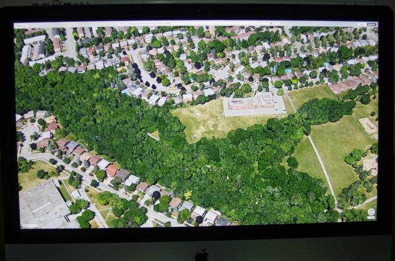 Mickey |
|
SidW
Lifetime Member
Posts: 1,107
|
Post by SidW on Mar 16, 2015 18:23:34 GMT -5
Phil, only found old and new maps so far. Wikipedia has this to say
"Padgate is a suburb of Warrington, Cheshire, England. During World War II it had a small RAF Station. RAF Padgate will be well-remembered by thousands of young men who were selected for RAF national service and on this site received their first taste of military discipline, ill-fitting uniforms and a severe haircut ...... The RAF station is now a housing estate, bordering Bennett's Rec where the Cheshire Cadets Drum and Bugle Corps are based and Cinnamon Brow. University Academy Warrington (a secondary school formally known as Lysander Community High School) is on this land."
|
|
SidW
Lifetime Member
Posts: 1,107
|
Post by SidW on Mar 17, 2015 8:57:39 GMT -5
Phil, the best I can find, aerial view of Padgate from NE (i.e. looking towards Warrington centre on horizon), taken 1946.  Some features were identified. There's a T junction just below centre; Station Rd to left, Cinnamon Lane right, Fearnhead Lane down to bottom, Old Poulton golf course bottom right. Should be enough to help you. Source: www.britainfromabove.org.uk/image/eaw001091 |
|
|
|
Post by philbirch on Mar 18, 2015 10:26:54 GMT -5
Thanks Sid, I understand exactly what I'm looking at. Fearnhead lane goes on now, roughly following the central 'road' in the picture, where the first crossroad is on the base is a new crossroads. All the streets are now named after aircraft and airbases - not necessarily WW2. Google maps reference. link |
|
jpp
Contributing Member

Posts: 47
|
Post by jpp on Mar 18, 2015 15:18:32 GMT -5
Warrington, St Helen, I had friends there, a long time ago i went on a school exchange to english Martyrs School with pupils, I remember quite well the town Hal and the Golden Gates, mut have pictures somewhere in a box...
|
|
Deleted
Deleted Member
Posts: 0
|
Post by Deleted on Mar 18, 2015 19:48:11 GMT -5
Here's a shot of our neighborhood. The square house in the middle of the photo with the hole in the middle is ours. In the summer we have a shade (seen in the photo) to make the center patio livable when the temperature gets up in the 90sF. We've been here 24 years. W.  |
|
SidW
Lifetime Member
Posts: 1,107
|
Post by SidW on Mar 18, 2015 20:58:23 GMT -5
Phil, I hope you're not kept awake by the eternal echo of thousands of boots marching and stamping from dawn to night on the drill square. Now one from our village, or rather outside, the view down the glen to the sea, then the island of Ven (where late mediaeval astronomer Tycho Brahe did his stargazing before moving to Prague, where he was assisted by the young Kepler, his observatory is still on the island), then on the horizon Denmark (the Zealand coast north of Copenhagen). This was all Denmark in those days until Sweden took it in the 17th century and did some pretty ruthless ethnic cleansing before marrying off their soldiers to the Danish widows.  Having started in a sombre vein, I felt I had to add the following, which is also a local postcard. It was sent by a neighbour's great uncle (who had left Germany before 1939) to his sister, in 1942, in Frankfurt am Main. Registered to be on the safe side. Look carefully at all the rubber stamps and jottings, that tell the whole story. The sister had already been deported to Theresienstadt Camp in Czecko-Slovakia, the card was duly forwarded, someone took the time to look her up and found she had already "died", they had a special rubber stamp ready for the situation (Gestorben Zuruck), all handled by the Central Office for Dealing with the Jewish Question in Bohemia and Moravia at the Theresienstadt Division, and returned to the sender. Along the way it picked up a swastika from Army HQ (censors?).  |
|
|
|
Post by John Farrell on Mar 18, 2015 23:51:36 GMT -5
A picture "snipped" from our local city website. My house is the one on Churchill st, No 23.  |
|
SidW
Lifetime Member
Posts: 1,107
|
Post by SidW on Mar 19, 2015 7:38:20 GMT -5
The village from the SW, we're somewhere at the back to the left on the top of the hill:  And from long ago, perhaps 100 years (no 1920s houses), from the same direction but different perspective, we'd be somewhere on those fields in top left quarter:  |
|
|
|
Post by philbirch on Mar 19, 2015 10:52:41 GMT -5
Wow Sid, thats an interesting postcard and such a sad story. It looks like a nice place where you live. John - not many cars where you live. Everyone at work?? My home- to be specific the one with the light on. This was about 5:30 am one January. I had to go out and snap the virgin snow.  |
|
|
|
Post by John Farrell on Mar 19, 2015 13:41:16 GMT -5
Phil - the picture was probably taken mid morning, on a Monday.
|
|
Stephen
Lifetime Member
Still collecting.......
Posts: 2,718
|
Post by Stephen on Mar 19, 2015 14:16:42 GMT -5
Old Postcard of Borstal, Nr City of Rochester, Kent, taken just before the war, the other view is as now, the houses on the right were removed to widen the road, and build retirement flats. There is a tree grown up in front of the far cottages, but mostly the same on the left, the General store is a Chinese take away, with a fish and chip shop where a public house, "The Star", once stood. Stephen. |
|


