Post by doubs43 on Jul 6, 2007 21:37:59 GMT -5
It was in June, 1972 when the Potomac and Monocacy Rivers flooded the towns of Point of Rocks and Buckeystown, Maryland, and other places. The following pictures were taken by my father with an Exakta VX-IIa on Panatomic-X rated at 100 and developed in Acufine.
The Baltimore & Ohio Railroad station at Point of Rocks, MD, just avoided the high waters. Earlier floods (1936 & 1942) weren't as considerate. The track on the right of the station goes to Washington, DC.

Looking West from the B&O station.

Two Maryland State Troopers in the foreground watch as a boat makes it way down the main road through Point of Rocks.

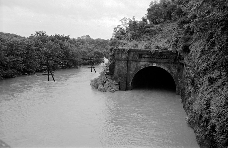
From the bridge crossing the Potomac River from MD to Virginia looking West. One track of the B&O goes through the tunnel while lower down along the trees is a second track..... well under water.
Some of the Point of Rocks residents displaced by the flood waters.

The Monocacy River at Greenfield, Maryland. The steel bridge was sturdy enough to withstand the flood waters.

Looking North on the main road through Buckeystown, Maryland. The waters of the Monocacy were probably 12~15 feet deep at the low point of the road which used to be a major North-South route that carried heavy traffic. The same road continues another 10 miles or so South to Point of Rocks.

Just East of Buckeystown this old single lane steel and plank bridge across the Monocacy was washed away. I've crossed it many, many times.

Fortunately, a new span was already in the works so down time for the bridge was minimal. Part of the old bridge is lying against the pillars of the new one.

Walker
The Baltimore & Ohio Railroad station at Point of Rocks, MD, just avoided the high waters. Earlier floods (1936 & 1942) weren't as considerate. The track on the right of the station goes to Washington, DC.
Looking West from the B&O station.
Two Maryland State Troopers in the foreground watch as a boat makes it way down the main road through Point of Rocks.
From the bridge crossing the Potomac River from MD to Virginia looking West. One track of the B&O goes through the tunnel while lower down along the trees is a second track..... well under water.
Some of the Point of Rocks residents displaced by the flood waters.
The Monocacy River at Greenfield, Maryland. The steel bridge was sturdy enough to withstand the flood waters.
Looking North on the main road through Buckeystown, Maryland. The waters of the Monocacy were probably 12~15 feet deep at the low point of the road which used to be a major North-South route that carried heavy traffic. The same road continues another 10 miles or so South to Point of Rocks.
Just East of Buckeystown this old single lane steel and plank bridge across the Monocacy was washed away. I've crossed it many, many times.
Fortunately, a new span was already in the works so down time for the bridge was minimal. Part of the old bridge is lying against the pillars of the new one.
Walker